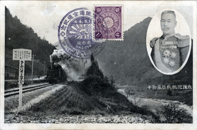
Completion of the Chuo Main Line Railway commemorative postcard, Nagoya, c. 1911, with an inset photo of Goto Shimpei, then then-Director of Japan Government Railways. The Kobu Railway opened the initial section of the Chūō Line from Shinjuku Station to Tachikawa Station in 1889, extending the line both west (toward Kofu) and east (toward Tokyo) until the company was nationalized in 1906. The Japanese Government Railways (JGR) then continued to extend the line, reaching Shiojiri in 1906 and beginning a line from Nagoya in 1900 to Shiojiri, connecting the two sections in 1910. (The last station on the Nagoya-Shiojiri section opened in 1911.) The main line roughly followed the course of the feudal Nakasendo Highway.
See also:
Tokaido Main Line, c. 1910.
Chuo Rapid Line (neé Kobu Line), Tokyo, c. 1910.
“Even before the promulgation of the Railway Construction Law, the need for building the Chuo Line west from the capital region had been strongly advocated, especially by the Japanese Army.
“At the time, the Army held the opinion that it would be disadvantageous from the point of view of national defence to build a westward-leading railroad next to the seacoast [even though the government was then constructing the Tokaido Main Line along the eastern seaboard from Tokyo to Kobe].
“The Army at the time visualized a hypothetical conflict in which foreign troop aggressors landing on Japanese soil would be repulsed by action within the country. If a strong and hostile foreign fleet should gain control of access to the sea, cruising freely along the coast, railroads built near the coast could be easily destroyed. Because Japanese troop movements could not in such an eventuality be made quickly, it was proposed to construct rail routes as far from the coast as possible.
“… Selection of the Chuo Line route gave rise to numerous debates and manoeuvres aimed at influencing decisions in one way or another … In February 1893 the Railway Committee decided that the Ghuo route would start at Hachioji and pass through Kofu, Suwa and Nishichikuma-gun.
“… The decision on the routing of the Chuo Line and the line’s subsequent opening indeed greatly affected the fortunes of the various local communities. The position of the spinning industry in the Suwa region became more stable, while industries in the Ina region, which failed to attract the railway, for a long time were destined to relative stagnation.
“In the To-no- region, where the rail line followed the river Toki, the town of Tajimi, located along the route, developed rapidly as a centre for pottery manufacture and wholesale trade, but Dachi, Oroshi and Kasahara, which were not on the route, were put in a disadvantageous position. Yamanashi prefecture, which had previously depended on trade routes from Shizuoka prefecture for bringing in daily necessities, virtually cut off this trade relation-ship after the opening of the Chuo Line and became much more closely linked with Tokyo.”
– Railway Construction as Viewed from Local Society, by Eiichi Aoki, 1980

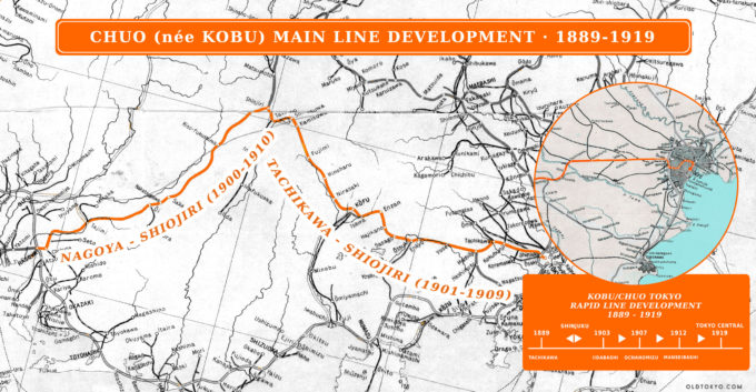
Map: Chuo (née Kobu) Main Line Developement (1889-1919). Connecting Tokyo with Nagoya, as the more defensible inland main line route favored by the military, the Chuo Main Line followed the general course of the feudal Nakasendo Highway. The inset illustrates the development of the Chuo Rapid Line development betweeen Tachikawa and Tokyo Central Station, 1889-1919. (Click to enlarge)

